| Subject: News From The Zetas. Part 2 of 2. |
| From: "John Winston" <johnfw@mlode.com> |
| Date: 11/04/2011, 22:04 |
| Newsgroups: alt.conspiracy.area51 |
Subject: News From The Zetas. Part 2 of 2. April
11, 2011.
This talks about a pole shift.
.............................................
.............................................
Despite the heroic efforts of technicians and engineers battling to prevent
a full nuclear meltdown at the quake-damaged Fukushima Daiichi plant,
r-dioactive material is still seeping into the surroundings of the power
station. Plutonium has been detected in soil samples near the plant. And
highly ra-ioactive water has been found for the first time outside one of
the reactor buildings on Monday, albeit in a tunnel. Rad-oactive iodine and
cesium have also been detected in sea water near the plant. These latest
reports of radioa-tive leaks - and the possibility that there may have been
a
partial meltdown in three reactors - raise questions about the immediate
dangers poised to human health and the environment.
How bad will it get, and will benign aliens be allowed to intervene again?
ZetaTalk
http://www.zetatalk.com/ning/02ap2011.htm
Explanation 4/2/2011: The lessons that Fukushima holds for the
establishment are being continued!
The Japanese g-vernment in particular has resisted admitting the
reality of what was happening at Fukushima. Only when the hard facts
were in the hands of the public did they admit what was happening to the
reactors which were in the process of slow meltdown. The full facts are
still not known to the public. Many d-aths will result from the Japanese
go-ernment sending in workers to their certain de-th, all to save face
and attempt to save the reactors. These were financial decisions, as
well as face saving maneuvers, none of which are gaining the sympathy of
the benign aliens who helped moderate the disaster during the quake.
Thus the reactors are being allowed to proceed in their dea-h march, as
the area will be too radioa-tive for operators, the two working reactors
buried alive along with the four that are disabled.
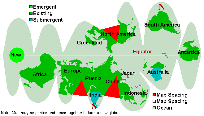
New Geography Confusion
The ZetaTalk New Geography map has been on the web since the start of
ZetaTalk, based on the words given by the Zetas and guidance to Nancy,
who generated this map in PC Paintbrush. Cut along the edges, past
around a small ball, and there you have the new globe. But questions
kept arising from those who complained they were not able to determine
their future Lat/Long effectively.
http://www.zetatalk.com/poleshft/pgeon.gif
Your future map and other discussions mention the new N Pole off the
eastern tip of Brazil, but this map made into a globe: shows that it would
be highly misleading to characterize the new N Pole as anywhere near
Brazil, because it is shown as west of the present southern tip of Africa.
Would it be too much trouble to give the present longitude and latitude of
what will be the future N Pole? Would the Zetas mind giving the present
latitude and longitude of the future N Pole?
So the new Lat/Long of the poles was given: ZetaTalk
http://www.zetatalk.com/ning/17jy2010.htm
Answer
Under our direction Nancy has ascertained via Google Earth that the new
N Pole will be at the current lat/long of 50S and 29W and the new S Pole
will be the current lat/long of 10N and 78E. These points are not on
opposites of the globe from one another today. The Pacific compresses,
the Atlantic widens, the S America Plate crunches through much of what
is now the Caribbean Plate, and all this and more reform the globe
somewhat so that geographical points are not relative to other geographical
points as they are today.
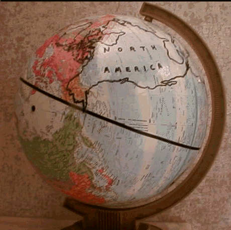
But confusion still ran rampant. In their response to this confusion, the
Zetas stated that it was not for lack of explanation on their part, but that
the shock of a new globe was too much, and the complainants were thus
refusing to visualize the new globe, even when it was in front of them. The
new globe had already been superimposed on an existing globe, as part of the
http://www.zetatalk.com/teams/tteam332.htm
Pole Shift TEAM efforts.
http://www.zetatalk.com/teams/poleshft/mikeg016.jpg
The map at New Geography shows the new positions of the equator and the
poles after the pole shift.
On that map, the new equator goes thru the old South Pole. Every equator is
a great circle of a sphere, and so if the new equator goes thru the old
South Pole, then - as a great circle - it must also pass thru its' antipode
at
the old North Pole. But, since the poles are on a diameter, that fact does
not
determine the old longitude of the new equator.
http://www.zetatalk.com/ning/16oc2010.htm
What is left is for you to be able to conceptualize this matter, and
not be rigid in your mindset. We have stated that the Pacific shortens,
primarily by folding near the Philippine Plate. The Atlantic will rips
apart, the Caribbean Plate and the tongue holding Indonesia will be
pushed down or ground up.
Great rifts will develop so that an inland bay is produced from Karachi
up into Russia, and the N American Seaway will widen greatly. If it is
beyond you to comprehend these changes, then simply look at the new
geography depicted and say "well, there it is".
Perhaps complaints will never stop coming, though when knowing where
the new Equator will run and the exact position of the new poles and
where the new continents will be when superimposed upon a globe, one
can estimate that Latitude of their new geography.
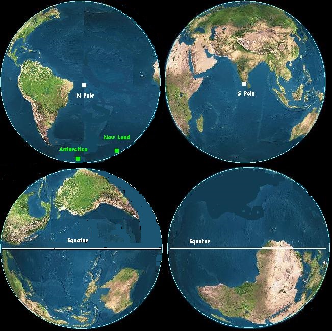
But complaints continued. This time, the Zetas led them by the hand.
I, Nancy, have since followed their directions, using images
http://www.fourmilab.ch/cgi-bin/Earth
from Fourmilab to produced a 2D image. But since denial and shock are with
us still, I don't expect this to end the questions.
http://www.zetatalk.com/newsletr/image018.jpg
I have a question about the overall movement of the two American
continents during the PS. Right now, they are in a certain relationship to
each other (longitudinally speaking).
For example, right now New York City is directly north of Bogota,
Colombia. Can the Zetas give us a better idea of just how much further
to the west (and north?) the SA continent will move in relationship to
the NA continent during the PS?
ZetaTalk
http://www.zetatalk.com/ning/02ap2011.htm
Comments
Apparently, nothing short of a new globe, drawn by ourselves, will suffice.
All you have to do is buy a cheap globe, trace the continents on a piece of
paper and cut them out ready to paste, paint the globe so it is a blank,
and paste the continents in their appropriate places aka Nancy's map and
Mike's globe photos.
Simple. Why is there this continuing confusion? This is at base a gasp of
disbelief. One does not want to contemplate such radical changes, so
one simply does not grasp the outcome. The outcome is what should be
focused on, for understanding.
Andrew's Video
Andrew, a staunch member of the
http://poleshift.ning.com/
Pole Shift ning Has produced two videos explaining the pole shift. The first
deals with the
http://www.vimeo.com/9104959
historical evidence of prior pole shifts, and is over 2:30 hours in length.
The
second, newly released, deals with the
http://www.vimeo.com/21878441
current signs that we are in another passage, and is 2:37 hours in length.
Both are fact filled and highly recommended.
You received this Newsletter because you subscribed to the
http://www.zetatalk.com/newsletr/subscrib.htm
ZetaTalk Newsletter service.
Part 2 of 2.
John Winston. johnfw@mlode.com