| Subject: Rain In Manila. |
| From: "John Winston" <johnfw@mlode.com> |
| Date: 21/06/2011, 16:40 |
| Newsgroups: alt.conspiracy.area51 |
Subject: Rain In Manila.
June 21, 2011.
As many of you know a little over a year ago I asked that people think
good thoughts about it coming some rain in Manila, because they had
been in a drought. Art Bell said that they needed rain because their lakes
were getting low that produce their electricity. Thanks to all of you who
may have helped to bring this rain about. It has now rained in Manila.
.......................................................
.......................................................
The ZetaTalk Newsletter
*Issue 246, Sunday June 19, 2011*
**
*Chile's Boiling River*
Pressure on the Andes has begun, as part of the S American roll. A rift
in the Earth 6 miles long and 3 miles wide opened up in Chile, spewing ash.
*IMAGE:* Puyehue Eruption <http://www.zetatalk2.com/newsletr/image092.jpg>
http://www.zetatalk2.com/newsletr/image092.jpg
3,500 Evacuate as Volcano Erupts in Southern Chile
June 5, 2011
http://www.foxnews.com/world/2011/06/05/3500-evacuate-as-volcano-erupts-in-southern-chile/
/One of the volcanos in the Caulle Cordon of southern Chile erupted
violently Saturday, billowing smoke and ash high into the sky and
prompting more than 3,500 people living nearby to evacuate. Authorities
initially said the Puyehue volcano was involved, but later said the
eruption was occurring about 2� miles from that peak. A rift more than
six miles long and three miles across was torn in the earth's crust. The
National Emergency Office said it recorded an average of 230 tremors an
hour./
This was not the Puyehue volcano, but the fissure system that is part of
the caldera.
Puyehue-Cord�n Caulle Volcano
http://www.volcanodiscovery.com/fr/puyehue-cordon_caulle.html
/Puyehue-Cord�n Caulle volcano in Central Chile is a complex of 2
volcanoes: Puyehue volcano and the fissure system of Cord�n Caulle./
The eruption from the fissure was not the only news, as a river nearby
began boiling from the heat of the Earth. Boiling rivers are not new, in
rock lying above areas subject to intense subduction. This part of the
Andes is a point where pressure to push over the Nazca Plate just to the
west is intense.
The Day the River Boiled
June 10, 2011
http://www.dailymail.co.uk/news/article-2002210/Chile-volcano-Eruption-turns-waterway-steaming-torrent.html
The usually chilly river temperature of six degrees has been raised to
an average of around 45 degrees by the eruption. /
Boiling rivers were reported in Velikovsky's book Worlds in Collision,
during prior pole shifts.
The traditions of the Indians retain the memory of this boiling of the
water in river and sea. On the North Pacific coast of America the tribes
insist that the ocean boiled: The Indians of the Southern Ute tribe in
Colorado record in their legends that the rivers boiled. Jewish
tradition, as preserved in the rabbinical sources, declares that the
mire at the bottom of the Sea of Passage was heated.
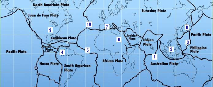
*Domino Plates*
The 7 of 10 scenarios depict plate movement around the world. On June
12, 2011 there was plate movement /worldwide/, almost simultaneously and
in a domino fashion, on several 7 of 10 scenarios.
*IMAGE:* 7 of 10 Scenarios
http://www.zetatalk3.com/newsletr/issue207.jpg
The 1st scenario involved a tipping of the Indio-Australian Plate such
that the border with Pakistan sinks by 10 feet. This happened during the
last half of 2010. Then the 2nd scenario where the Sunda Plate, the
plate tongue holding Indonesia, would be pushed down under the curve of
the Indo-Australian Plate. This has been ongoing since December 23, 2010
http://www.zetatalk.com/newsletr/issue218.htm
. Then the 3rd scenario
where the Philippine and Mariana Plates would fold, compressing the
Pacific. This was evident by February 20, 2011
http://www.zetatalk4.com/newsletr/issue229.htm
and additional evidence
is now in hand with flooding in Kyushu. These Japanese Islands, on the
southern tip of Japan, are actually on the Okinawa platelet, which would
lose support as the Philippine Plate tips. Note the date, June 12, 2011.
*ZetaTalk*Prediction
http://www.zetatalk6.com/info/tinfx029.htm
*12/11/2010: *The Philippine Plate is also pushing under the south
island of Japan, and the point of juncture at Mount Fiji, a three-plate
boundary where the Pacific and Philippine plates slide past each other,
will be a focus.
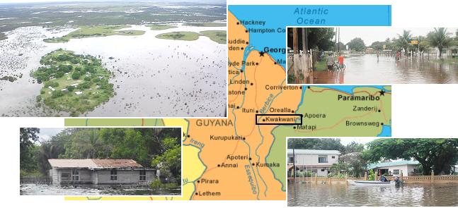
The 4th scenario is the S America roll. As the top part of S America
pulls west while the long spine of the Andes resists being pulled over
the Nazca and Cocos Plates, it bends a bit on the eastern side. The bay
at Buenos Aires will split open further during the pole shift, per the
Zetas, and flooding in Brazil has already been attributed to this
stretch. Could this include Guyana, where sudden flooding without rain
has afflicted a river front town there? Note the date on this article -
June 12, 2011.
*IMAGE:* Guyana Flooding
http://www.zetatalk7.com/newsletr/image083.jpg
*IMAGE:* Eritrea Volcanoes
http://www.zetatalk9.com/newsletr/image085.jpg
Strong Earthquakes are Setting off a Powerful Volcanic Eruption in Eritrea
June 12, 2011
http://eastafro.com/Post/2011/06/13/strong-earthquakes-are-setting-off-a-powerful-volcanic-eruption-in-eritrea-based-on-satellite-images
/During the late afternoon and evening of June 12 2011, a series of
moderate earthquakes struck the Afambo, Eritrea area. Based on the
earthquake pattern and the locations of the epicenter, volcano activity
seemed imminent.
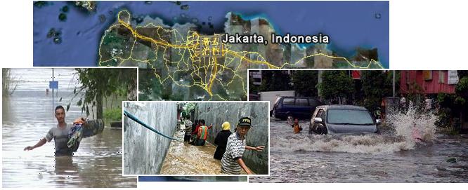
*Sinking Cities*
The Zetas have predicted that ultimately Jakarta will lose 80 feet in
sea level elevation, Singapore closer to 60 feet, Bangkok and Manila 40
feet, and Hong Kong
http://www.zetatalk2.com/newsletr/issue243.htm
20
feet during the sinking of the Sunda Plate, a 7 of 10 scenario. Where
delays have set in, proceeding more slowly than expected, sinking on the
Sunda Plate is occurring. The Zetas were asked to address the extensive
flooding that Singapore is experiencing lately. Where is the line drawn?
In cities protected by dykes and experiencing rainstorms, how can one
determine sinking?
----------------------------------------
The third sign is that those areas that are at or below the new sea
level will refuse to drain unless pumping is done and dykes are in
place. Those areas that are below the new sea level will become inland
seas, or an encroachment of the sea. This is often blamed on erosion,
the tides eating the land, another establishment excuse during the
sinking process.
The fourth sign is that despite dykes and pumping action, basements or
below ground parking will become permanently flooded, beyond what any
type of pumping can overcome. This will be blamed on recent rains for as
long as the public can tolerate such excuses. Still, the establishment
will continue to talk about improved drainage systems, stronger dykes,
and silting of river bottoms.
The proof that sinking has occurred will only be in hand when the sea
is washing inland along roads not protected by dykes. Or the sea is
washing over bridges connecting islands in Singapore or Hong Kong where
the bridge itself is at a known elevation and this is supposed to be
well above sea level. Or where the dykes are broken, and the sea has
flooded the protected area so the new sea level can be clearly determined.
*IMAGE: *Jakarta
http://www.zetatalk5.com/newsletr/image087.jpg
Jakarta: Residents Pondoklabu Restless, 2 Months Not Visit Fading Floods
May 25, 2011
http://www.beritajakarta.com/2008/id/video_play.asp?vid=3149
In the past two months hundreds of homes on Bango Road, Pondoklabu
District, South Jakarta submerged 1 meter high flood that do not
subside. Parties and related officials Pondoklabu village now find out
the cause of why the flood did not recede as well.
Jakarta Plans to Build Dikes to Prevent Water
May 31, 2011
http://kawasanindustri.com/jakarta-akan-berencana-membuat-tanggul-untuk-mencegah-air/
/Indonesia plans to build a large dike to prevent the sea from breaking
over the capital because of land subsidence and sea level rise. The rate
of decline in soil faster than rising sea levels, and both resulted in
the phenomenon of flooding on the north coast of Java, including
Jakarta. The city has installed high-powered pump in the northern part
of town, where the land is below sea level, as part of flood control
efforts./
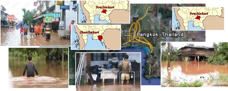
IMAGE:
Bangkok
http://www.zetatalk6.com/newsletr/image088.jpg
Bangkok: Beware Flash Floods.
May 29, 2011.
http://soclaimon.wordpress.com/2011/05/29/
/Nakhon Nayok, Prachin Buri, Chanthaburi, Trat, Ranong, Chumphon Beware
flash floods. Multi-flow and flash during this period. Bangkok and its
vicinity.
Bangkok: Heavy Rains Flooded Throughout the City at Various Locations.
June 06, 2011.
http://www.thairath.co.th/content/region/177073
Streets at various locations in Bangkok. Sinking underwater.
Manila was flooded in late May, prior to tropical storm Dodong which did
not rise to the level of a typhoon or cyclone.
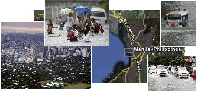
*IMAGE:*
Manila
http://www.zetatalk7.com/newsletr/image089.jpg
Rain Caused by the Southwest Monsoon Flooded Parts of Metro Manila
May 28, 2011
http://www.pia.gov.ph/?m=1&t=1&id=35086
Rain caused by the southwest monsoon flooded parts of metro Manila. It
recorded knee-deep level or 19 inches of floodwater.
Manila: Dodong' Dumps Rain on Luzon
June 10, 2011
http://www.philstar.com/Article.aspx?articleId=694706&publicationSubCategoryId=63>
Vehicles pass through gutter-deep floodwaters along United Nations
Avenue in Manila following heavy rains yesterday.
Part 1.
John Winston. johnfw@mlode.com