* *** ***** ******* ********* *********** ************* The Mothership
Product Description
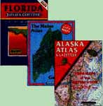
Delorme State Atlases
New and Used
The best local map coverage for travel and exploration
Many new entries added
Our Item Code: (See variation below)
Postage Code: std
Large format atlases
Trade Paperback
Cover Size: 11 x 15 inches
Delorme Mapping, Various
ISBN: 89933-general
Country of Origin: USA
Added to Catalog: 12/16/96
WIRT: 443540x5
Availability: This item is usually in stock and available for immediate
Priority Mail shipment. Order it today (by 8pm Eastern/5pm Pacific),
and you will probably have it in 2-3 days (in USA).
Features: Oversized, Table of Contents, Index, Bibliography, Appendix, Maps
Delorme Mapping produces an impressive series of detailed state atlases for the majority of
U.S. States. Drawn from government data, these atlases provide topographic maps of
every part of the state and are the equalivalent of buying dozens of USGS maps.
We stock all Delorme atlases at standard retail price -- plus an assortment
of used copies and previous
editions at significant discount.
Unless specified otherwise, all items are normally in stock for immediate shipment
(subject to occasional shortages). Order today, and you should
have your atlas in 2-3 business days.
In response the popularity of GPS receivers, DeLorme has revised many of
its atlases to include latitude/longitude grid marks along the borders of each map.
If these marks are not important to you, you can save money by ordering the
slightly older
non-GPS version.
Because it makes a difference to some people, we have tried to specify
"with GPS" or "no GPS" to indicate the presence of GPS grids for each map.
Those marked "semi GPS" have no grids, but the latitude and longitude is
marked at the four corners of each map.
(You can use a ruler to figure approximate coordinates.)
Apart from GPS grids, there is very little difference between the editions.
The atlases below are in alphabetical order.
All maps are new unless "used" is specified.
(The first item listed for each state is a new copy.)
Most of our used copies are in very good condition, having only been used
for office reference.
See also: USGS Topographic Maps
Scale: 1:300,000 for populated areas, 1:1,400,000 for wilderness.
$19.95 book3
deak_
Alaska (slightly used, semi GPS)
$13.95 book3
deal
Alabama (new, with GPS)
Scale: 1:182,000
16.95 book2
deaz
Arizona (new, with GPS)
Scale: 1:250,000
$16.95 book2
deaz_
Arizona (slightly used, with GPS)
$12.95 book2
dear
Arkansas (new, with GPS)
Scale: 1:200,000
$16.95 book2
denca
Northern California (new, with GPS)
Scale: 1:150,000
$16.95 book2
denca_n
Northern California (new, semi GPS)
$12.95 book2
denca_
Northern California (used, semi GPS)
This copy is worn but complete.
$8.50 book2
desca
Southern California (new, with GPS)
Scale: 1:150,000
$16.95 book2
desca_n
Southern California (new, semi GPS)
$12.95 book2
desca_
Southern California (used, no GPS)
This copy is very worn but complete.
$5.95 book2
deco
Colorado (new, semi GPS)
Scale: 1:160,000
$16.95 book2
deco_
Colorado (slightly used, semi GPS)
$12.95 book2
dect
Connecticut & Rhode Island (new, expected Mar. 99)
Expected in March 1999.
Orders now accepted.
$16.95 book2
defl
Florida (new, with GPS)
Scale: 1:150,000
$16.95 book2
dega
Georgia (new, with GPS)
Scale: 1:182,000
$16.95 book2
dehi
Hawaii (new, expected Mar. 1)
Expected Mar. 1, 1999
$16.95 book2
deid
Idaho (new, semi GPS)
$16.95 book2
deid
Idaho (slightly used, semi GPS)
Scale: 1:250,000
$10.95 book2
deil
Illinois (new, semi GPS)
Scale: 1:150,000
$16.95 book2
dein
Indiana (new, with GPS)
Scale: 1:156,000
$16.95 book2
deia
Iowa (new, with GPS)
Scale: 1:200,000
$16.95 book2
deks
Kansas (new, with GPS)
Scale: 1:200,000
$16.95 book2
deky
Kentucky (new, with GPS)
Scale: 1:150,000
$16.95 book2
dela
Louisiana (new, with GPS)
Scale: 1:182,000
$16.95 book2
deme
Maine (new, with GPS)
$16.95 book2
deme_
Maine (used, no GPS)
Maps are in the older Delorme format, using hash marks for topography rather
than contour lines.
$7.50 book2
demd
Maryland/Delaware (new, with GPS)
$16.95 book2
dema
Massachusetts (new, with GPS)
1999.
$16.95 book2
demi
Michigan (new, with GPS)
1:150,000
$16.95 book2
demi
Michigan (new, semi GPS)
$12.95 book2
demn
Minnisota (new, with GPS)
1:190,000
$16.95 book2
dems
Mississippi (new, with GPS)
Scale: 1:182,000
$16.95 book2
demo
Missouri (new, with GPS)
Scale: 1:200,000
$16.95 book2
demt
Montana (new, with GPS)
Scael: 1:250,000
$16.95 book2
N-Z
dene
Nebraska (new, with GPS)
Scale: 1:200,000
$16.95 book2
denj
New Jersey (new, expected April 99)
Expected April 99.
Orders now accepted.
$16.95 book2
denh
New Hampshire (new, semi GPS)
Including street maps of Manchester, Concord, Nashua and Portsmouth.
$16.95 book2
denm
New Mexico (new, with GPS)
Scale: 1:300,000
$16.95 book2
nmatlas
New Mexico Benchmark Atlas (new, no GPS)
Scale: 1:525,000, plus 1:26,000 and 1:50,000 for cities.
An atlas from a competing company, Benchmark Maps.
Similar to Delorme only in size. Provides two sets of
maps: one for land use (private, BLM, etc.) and one for shaded relief
topography (neither of which are provided by Delorme).
Includes street maps for Alburquerque, Las Cruces, Rio Rancho,
Roswell and Santa Fe. (It is hard to recommend one of these atlases
over the other; each has its strengths.)
$14.95 book2
nmatlas_
New Mexico Benchmark Atlas (slightly used, no GPS)
$9.95 book2
nmroads_
The Roads of New Mexico (used, no GPS)
1990. Scale: 1:208,000.
Yet another large-format atlas. This one is based on county road maps from
the State Dept. of Transportation. Includes only roads, park boundaries and
township/range grids.
Bland compared to the above two atlases, but may provide some supplemental
information on the condition of roads.
6.50 book2
deny
New York (new, semi GPS)
$16.95 book2
deny_
New York (slightly used, semi GPS)
Older edition.
$9.95 book2
deunyc
Upstate New York Cities (new, no GPS)
City street maps for major New York State cities (excluding the New York City area
and Long Island).
1990. Publisher: Shearer.
Based on county road maps from
the State Dept. of Transportation. Includes only roads, park boundaries and
township/range grids.
Could be a useful supplement to the DeLorme atlas for the condition of roads.
6.50 book2
deut
Utah (new, with GPS)
Scale: 1:250,000
$16.95 book2
devt
Vermont (new, with GPS)
Scale:
Includes street maps of 50 cities and towns.
$16.95 book2
devt_
Vermont (used, no GPS)
In earlier Delorme format, with hash marks for topography instead of
contour lines.
$6.50 book2
deva
Virginia (new, semi GPS)
Scale: 1:150,000
$16.95 book2
deva_
Virginia (used, semi GPS)
$8.50 book2
dewa
Washington (new, with GPS)
$16.95 book2
dewa_n
Washington (new, semi GPS)
$12.95 book2
dewa_
Washington (used, semi GPS)
$8.50 book2
dewv
West Virginia (new, with GPS)
$16.95 book2
dewi
Wisconsin (new, semi GPS)
Scale: 1:150,000
$16.95 book2
dewy
Wyoming (new, semi GPS)
Scale: 1:250,000
$16.95 book2
dewy_
Wyoming (slightly used, semi GPS)
$12.95 book2
Other Countries
AustraliaAtlas
Australia Road Atlas (new)
1997. Publisher: HEMA Maps. 10x13.5"
All of Australia shown in a variety of scales (more detailed in populated areas).
This is equivalent to a Mobil road atlas in the U.S.
(1/24/99)
19.95 book2
BritainAtlas
Britain Road Atlas (new)
1996, 140pp, 11x15".
Publisher: American Automobile Association.
(Idential to AA Atlas in Britain.)
Detailed road atlas for all of Britain,
including a less detailed map of Ireland.
(1/24/99)
1998. 11x15". Publisher: Delorme.
Delorme's atlas of the world.
Maps of 192 countries, arranged by continent.
Each map shows roads, cities and topography in shaded relief.
The detail is necessarily limited by the wide scope.
The margins include facts about each country.
This is a very attractive atlas, but not nearly as useful as
the state atlases.
(1/24/99)
These large-format atlas provided
detailed topographic maps of each state.
The series currently includes atlases for 30
states, from Alaska to Florida, with each state covered in
its entirety. Big, full-color maps offer the most
comprehensive and up-to-date detail available and can
save hundreds of dollars in USGS topo maps. The Gazetteer
sections are loaded with information on places to go and
things to do, from hot springs to caves to historic sites. Most
atlases feature elevation
contours, major and minor road,
and foliage overprints. With their
easy-to-use format,
these atlases are the ultimate trip planners and take-along
guides for any kind of back-road or off-road adventure.
Also handy for at-home research.
We stock
all DeLorme state atlases for immediate shipment!-- Glenn Campbell
Reservations
For local roads,
these atlases do not clearly distinguish dirt roads from paved ones,
or the quality of dirt tracks. When travelling off-highway,
never trust your life to this or any other atlas. You should also
carry the state's official highway map for better for overview
of major roads.
Comparison to Other Books
Delorme offers by far the best state atlases available,
well worth the price for anyone visiting a state.
This catalog provides the sole financial support
for the Ufomind website
and our many free on-line services....
Your purchases keep us going!
If you find out about a book here, please order it here.
 Many new entries added

