Book Catalog
Area 51 Satellite Image Poster
|
Our Review |
Opinion of the webmaster, subject to debate |
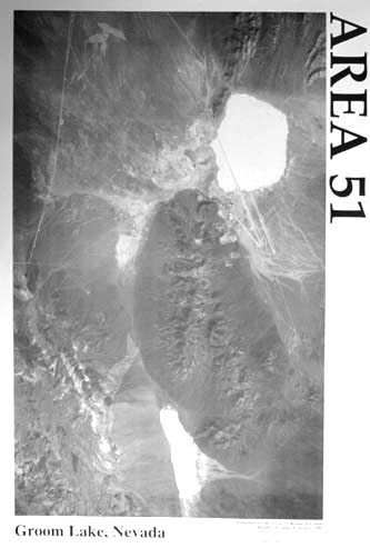
This is the first affordable satellite image available to the public.
This detailed black-and-white image shows both the Groom Lake
and Papoose Lake areas, with detail sufficient to count
the buildings and judge the quality of the roads.
We are not exactly sure where this image came from, since the
original arrived from an indirect source,
but it is probably not classified.
This image is consistent with others available from the
Russians for hundreds of dollars.
Our price of five bucks is ridiculously low,
but we think the image should be available to everyone.
The state of runway construction suggests that the photo
was taken in the early 1990's.
The image covers an area of approximately 12 miles by 20 miles.
That's 240 square miles you just can't get to, and
this poster may be the best overview you'll have of it.
-- tm/gc
Larger Image of Product
This catalog provides the sole financial support
for the Ufomind website
and our many free on-line services....
Your purchases keep us going!
If you find out about a book here, please order it here.
|
|
|
Information from the Publisher |
Always supportive |
As we were working late one night at the Research Center
(It was a dark and stormy night.), we
heard some faint scuffling noises on the doorstep. Cautiously
opening the door
(fearful of certain drunken bar owners),
we were surprised to find a bundle in a basket. The
attached note said the former owner was unable to properly care for
this package any longer, and perhaps it would have a better home and
future with the Research Center. Unwrapping the swaddling, what did we
find, but a satellite image of our favorite secret base!
As is obvious from the origins of this orphaned image, we
have little hard data on its background. It appears the original B&W
photo, from which this poster was produced, has a resolution of about
2-5 meters. Certainly not of the "license plate reading" category, but
still a generous source of
intelligence data. People knowledgeable of Groom
history suggest that it was taken around 1991,
based on runway construction. Beyond that, we know
little, but have grown to love it as one of our own.
Naturally, since this is a poster and not a photographic print,
there is a slight loss of
resolution due to the halftone screening process,
and the contrast is not quite as dark as we would like.
This is offset by being able
to offer them at a much lower price than a comparable photographic
print. Still, buildings, roads, toxic waste dumps and major features are
plainly visible, and the image provides an invaluable
reference guide to the entire
Groom/Papoose area. Here's a little piece of the black world you can hang
in your office or den, and the Research Center brought it to you first.
The image on the poster is about 14" by 23" in size, and has a scale of
approximately 1" = 0.85 miles (1:53,800). The poster is printed on
glossy white stock.
Orientation: Top is north (when "Groom Lake, Nevada" is at bottom).
Rachel is out of view above the top of the image.
Some highlights on the image:
- Shows the entire extend of the Groom Lake base, including the full length of
both runways.
- The entire Papoose lakebed is seen. What is most interesting about the
area is there's nothing there -- not the slightest hint of
buildings or construction. All the roads in and out of the area
appear to be narrow, unmaintained "two-tracks."
- The entire Papoose Mountain Range is shown.
A maintained road is clearly seen leading from the west side of the Papoose
Range deep into the mountains.
- Area 13, site of a plutonium dispersal test, is visible as a
pelican-shaped scar in the upper right.
- A similar scar north of the Papoose lakebed suggests either a
range fire or another dispersal test.
(One non-alien rumor about the Papoose area says that some
particularly nasty and still unannounced nuclear experiment went on there.)
- The entire extent of this image is on restricted land you cannot visit.
- Not shown: Freedom Ridge and White Sides,
Bald Mountain, Rachel, Route 375.
|
Indexing Information |
Other Relevant Ufomind Pages |
Related Pages & Products
Related Books

To report a bad link or find out more about an entry,
click on its number.
Only the Webmaster can add links to this page.
|
 By Unknown Source