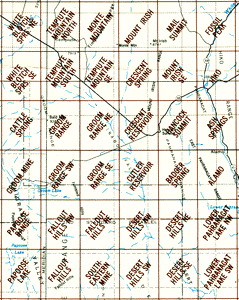
36 detailed maps of Groom Lake, Tikaboo Valley and vicinity
By USGS
Rolled Map In USA, the postage charge for maps is $4.00, regardless of how many you order.
|
|
Variations Available -
Abbreviations Used
To add an item to your shopping cart or place an order, click on the checkbox beside the item code and press the "Add..." button at the bottom. | |||
| Detailed topographic maps of Groom Lake, Papoose Lake, Tikaboo Valley and
vicinity. This page lists 36 maps in the 7.5 minute series (the most detailed
available).
See key map (110k).
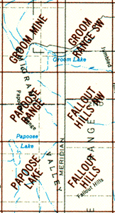
Our most popular maps are Groom Mine, Papoose Range, Papoose Lake (shown above and in this larger image) and Badger Spring (for Tikaboo Peak, overlooking Area 51). Although the first two maps are the site of a large secret Air Force base, no military facilities are shown, only the topography and a few dirt roads. WARNING: Although most of these maps were updated in the 1980s, they do not reflect recent expansions of the military boundaries. Do no rely on these maps to tell you where the current boundaries are. | |||
| Code | Description | Price | |
| error | Error in Product Code: m100pr () For all of the area covered by the more detailed maps below. | $0.00
std
| |
| error | Error in Product Code: m100tr () For Rachel and area north of Area 51. | $0.00
std
| |
sat![]() |
Area 51 Satellite Image Poster | $5.00
poster
| |
mapset![]() |
Set of 3 Groom Lake maps | $20.00
map
| |
| tnv0005 | Alamo, Nevada | $5.50
map
| |
| tnv0006 | Alamo NE, Nevada | $5.50
map
| |
| tnv0007 | Alamo SE, Nevada | $5.50
map
| |
| tnv0021 | Ash Springs, Nevada Shows sinkhole in mountains above Ash Spring. | $5.50
map
| |
| tnv1460 | Badger Spring, Nevada Tikaboo Peak and the dirt road approach to it. | $5.50
map
| |
| tnv1915 | Cattle Spring, Nevada | $5.50
map
| |
| tnv1452 | Crescent Reservoir, Nevada Includes the area of the "Black Mailbox" frequented by UFO watchers. | $5.50
map
| |
| tnv1686 | Crescent Spring, Nevada | $5.50
map
| |
| tnv1453 | Cutler Reservoir, Nevada | $5.50
map
| |
| tnv0311 | Delamar Not shown on key map. Located two maps east of Alamo NE. Delamar ghost town, including a network of rugged roads around it. | $5.50
map
| |
| tnv0316 | Delamar Lake Not shown on key map. Located just east of Alamo SE. Large, public dry lake bed, site of annual rocketry meets and some military exercises. Delamar Lake is known as "Texas Lake" to military aviators because it appears to be shaped like the state of Texas. | $5.50
map
| |
| tnv0327 | Desert Hills NE, Nevada | $5.50
map
| |
| tnv0328 | Desert Hills NE, Nevada | $5.50
map
| |
| tnv0329 | Desert Hills SE, Nevada | $5.50
map
| |
| tnv0330 | Desert Hills SW, Nevada | $5.50
map
| |
| tnv2014 | Fallout Hills, Nevada | $5.50
map
| |
| tnv1451 | Fallout Hills NE, Nevada | $5.50
map
| |
| tnv2015 | Fallout Hills NW, Nevada | $5.50
map
| |
| tnv0461 | Fossil Peak, Nevada | $5.50
map
| |
| tnv2057 | Groom Mine, Nevada Most of Groom Dry Lake, as well as the Groom and Black Metal mines. No facilities show, only a few dirt roads. | $5.50
map
| |
| tnv2059 | Groom Range, Nevada | $5.50
map
| |
| tnv1454 | Groom Range NE, Nevada White Sides mountain, now off limits. | $5.50
map
| |
| tnv0544 | Groom Range SE, Nevada | $5.50
map
| |
| tnv2060 | Groom Range SW, Nevada | $5.50
map
| |
| tnv1455 | Hancock Summit, Nevada | $5.50
map
| |
| tnv0574 | Hiko, Nevada | $5.50
map
| |
| tnv0575 | Hiko NE, Nevada | $5.50
map
| |
| tnv0576 | Hiko SE, Nevada | $5.50
map
| |
| tnv0744 | Lower Pahranaget Lake, Nevada Wildlife Refuge. | $5.50
map
| |
| tnv0745 | Lower Pahranagat Lake NW, Nevada | $5.50
map
| |
| tnv0746 | Lower Pahranagat Lake SE, Nevada | $5.50
map
| |
| tnv0747 | Lower Pahranagat Lake SW, Nevada | $5.50
map
| |
| tnv1664 | Mail Summit, Nevada | $5.50
map
| |
| tnv1666 | Meeker Peak, Nevada Not shown on key map. Immediately north of Monte Mountain. Coveres the southern half of the Worthington Mountains, including Leviathan Cave. Essential if you want to hike to Leviathan (which is best reached by hiking over the mountains from the east). | $5.50
map
| |
| tnv2180 | Monte Mountain, Nevada | $5.50
map
| |
| tnv1667 | Mount Irish, Nevada | $5.50
map
| |
| tnv1680 | Mount Irish SE, Nevada | $5.50
map
| |
| tnv1669 | Murphy Gap, Nevada Not shown on key map. Immediately north of Mount Irish. | $5.50
map
| |
| tnv2236 | Papoose Lake, Nevada Associated with the claims of Bob Lazar. Most of the lakebed is shown. (See Papoose Range for the northern tip.) No facilities shown, only a few dirt roads. | $5.50
map
| |
| tnv2237 | Papoose Range, Nevada Most of the Groom Lake base should located within the area of this map, although nothing is shown on the map except a few roads. | $5.50
map
| |
| tnv1456 | Southeastern Mine, Nevada | $5.50
map
| |
| tnv2356 | Tempiute Mountain North, Nevada Includes town of Rachel, although map shows no buildings. | $5.50
map
| |
| tnv2357 | Tempiute Mountain SE, Nevada | $5.50
map
| |
| tnv2358 | Tempiute Mountain South, Nevada | $5.50
map
| |
| tnv2428 | White Blotch Spring NE, Nevada Sand Spring Valley. Includes dry lake bed near Rachel. | $5.50
map
| |
| tnv2431 | White Blotch Spring SE, Nevada | $5.50
map
| |
| tnv1672 | Worthington Peak, Nevada Not shown on key map. North of Meeker Peak, which is north of Monte Mountain. Northern half of Worthington Mountains. Includes townsite of Freiburg.
Note: We also stock most of the maps surrounding this area on all sides. Call or email us for information. | $5.50
map
| |
|
Place a checkmark beside the items you want to order, then press the button above. (Or click on "Add to cart" beside each item.) To order by phone: (702) 227-1818 (8am-9pm Pacific) If you encounter any problems with the shopping cart, please tell us, providing as many details as possible. | |||
|
|  Information from the Publisher | Always supportive  |
![]() |
|  Indexing Information | Other Relevant Ufomind Pages  |
|