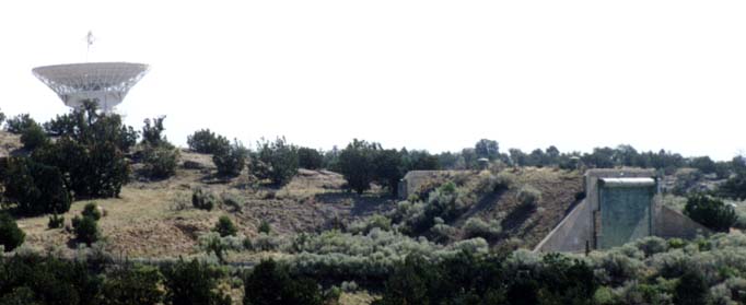
Building TA-33-25 and the NRAO antenna
Robert Collins' report, first published on the web in August 1996, recounts the claims of an unidentified Air Force Lt. Colonel who says extraterrestrial technology has been housed in a large underground complex below TA-33 (or with an entrance there). The report is accompanied by two photos and a map. Here is an excerpt (as of 8/18/96):
Fig. 1 shows the area adjacent to the Bandelier National Forest on Rt. 4 (forest location & Los Alamos Nat'l. Lab shown on the map circled in red). In Fig. 1 one can see a bunker. This bunker is representative of the many bunkers that dot the side of this ridge and valley area. Located just over the hill area where this bunker lies is a huge hangar bay door (not shown) according to a Ret. AF Lt. Col. Fig 2 shows Tech Area 33 entry way at Los Alamos. The road shown in this entry way reportedly leads in one direction off to the left and down to this huge bay door on the bottom "south" ridge area according to this same AF Lt. Col. This is said to be were many of the recovered "alien" artifacts were brought in. One example of this is when they would try to bring recovered "saucers" through this bay door and more often than not they would have to "tilt" the recovered "saucer" up on its side to get it through the door. This huge bay door entry is said to lead to a six level structure under the surface.On my visit, I located the bunker and gate pictured and described in this report. The bunker is building TA-33-25 on the South Site of TA-33. There does not seem much opportunity for big bay doors, however. The site of TA-33 is on top of a mesa. It is exposed all around and could easily be viewed and visited by hikers. Security is apparently lax, and apart from some fences around a few limited areas, a bold hiker could probably explore the site easily. There have been some minor underground structures built here for the testing and storage of explosives and radioactive materials, but there is no obvious evidence of major excavation. In all, TA-33 is such an open and casually controlled site that it is hard to imagine anything very secret going on here.This underground complex is part of a greater complex called "Dulce" (this was the code name). The "Dulce Complex" or Area "E" is composed of sixty buildings: some are underground, some are revetments, and some are bunkers. Badges with a color security system is in effect. All this according to a key government source who had been there in circa 1978/79. His words to me: "You should have seen what I have seen." The underground part of the facility is estimated to be over a 100++ ft down in this mountain ridge area close to the national forest. This area also lies just outside the main lab complex at Los Alamos (see map ).
Note: In addition to the "Dulce Complex" there was a reported newer structure built in the late seventies that was described as a three story underground facility. This facility may or may not be physically connected to the "Dulce Complex."Now, the big bay door entry represents the "back door." The "front door entry" is suspected to be back down the hill going in an easterly direction away from TA 33 along Rt. 4. At the bottom of this hill is another Tech Area with controlled access. People who have worked in Tech Area 33 know about underground facilities there (not related to this subject) but, are not apparently aware of just what�s behind that huge bay door which according to this same Ret. AF Lt. Col. which lies further down the ridge line. And, just like at WPAFB, Ohio, an estimated 99+% of the people assigned to Los Alamos Labs don't know of the existence of this reported underground six story facility. Or, if they knew of it they don't know what its used for -- or no "Need to Know."
According to our key government source this six story underground building is said to be highly secure with floor access controlled by tubes that only go down and a super secure up access by elevator only. This security system also holds true for the reported newer three story structure. This same source has said that within this "Dulce Complex" or Area "E" sometimes refereed to as Area 53 was were the first reported EBE was kept. EBE-1 was kept there until it was said to have died on June 18th, 1952 from an unknown illness.
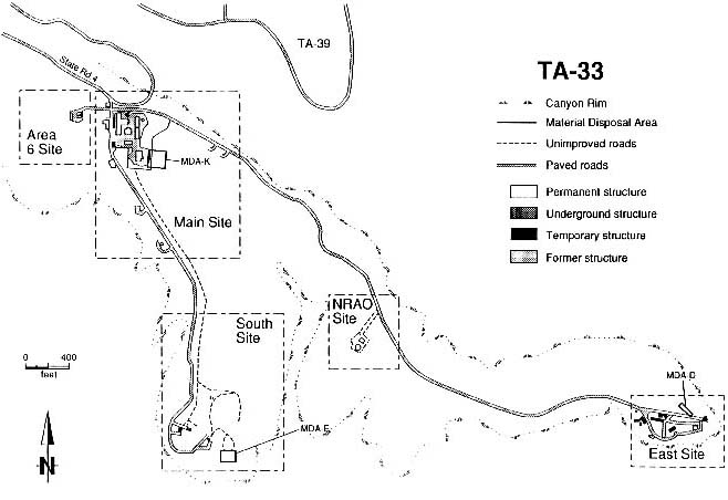
The mesa occupied by TA-33 is bounded by three canyons: (1) Chaquehui Canyon on the west, between TA-33 and Bandelier National Monument; (2) White Rock Canyon of the Rio Grande on the south; and (3) Ancho Canyon on the east, between TA-33 and TA-70. On the north, the mesa countinues toward the mountains along roughly the path taken by Route 4. This mesa is knowns as Frijoles Mesa, with TA-33 at its extremity.
TA-33 was created in 1947 as a test site for weapons experiments using conventional high explosives, uranium, and beryllium. Polonium was used as a radiation source. The tests were conducted primarily to verify designs of nuclear weapons components called initiators. The experiments were performed in underground chambers, on surface firing pads, and at firing sites equipped with large guns that fired projectiles into catcherberms. These activities ceased in 1972. A high-pressure tritium facility was operated at the area from 1955 until late 1990. Current activities are centered primarily at Main Site, located near the entrance gate, with Laboratory groups occupying portions of the office buildings. Other small buildings and surface areas are also used. An antenna of the National Radio Astronomy Observatory Very Long Baseline Array radiotelescope was sited at TA-33 in 1985 and is still operational. [Page 1-3]Present Land Use. TA-33 is designated as a multiuse experimental science zone (EX-4) by the Los Alamos National Laboratory Site Development Plan (Pava 1990, 0368). Although the site is remote and its use is constrained by limited utility service, "it has proven ideal for experiments not requiring daily oversight, or those requiring isolation or that are sensitive to electromagnetic interference" (Pava 1990, 0368). Current and recent activity at TA-33 has been concentrated in the area near the entrance from State Road 4, where approximately 60 full-time employees occupy the main office buildings. The only other active sites are an antenna that is part of the National Radio Astronomy Observatory's Very Large Array and a number of smaller antennae operated by LANL for atmospheric observations; these are visited periodically by maintenance workers. [Page 1-7]
Future Land Use. Both TA-33 and TA-70 will eventually be released to the control of the adjacent Bandelier National Monument. Recreational use and limited construction will then occur on the site. [Page 1-8]
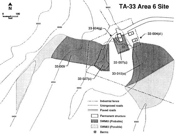
History. TA-33 was established in 1947 as a substitute test site for weapons components experiments then being conducted at Trinity Site in southern New Mexico. The facility was built for a weapons testing group, W-3. The land was previously owned by the US Forest Service. Experiments conducted at TA-33 involved testing of beryllium-containing initiators. Electronics trailers serving remote-sensing towers for atmospheric studies are parked at former firing sites. Office buildings and laboratories are in use at Main Site. A high-pressure tritium facility was operational at Main Site until late 1990. [Page 2-1]Current Activities. Current activities at TA-33 are centered primarily at Main Site. International Technology Group (IT-6) occupies laboratories and offices. Other small buildings are used for storage by groups from the Earth and Environmental Sciences (EES) Division. These buildings and outside areas are used primarily for storage of rock core samples that have been taken in support of the Hot Dry Rock projects at Fenton Hill. The National Radio Astronomy Observatory (NRAO) Site consists of an 82 ft diameter radiotelescope antenna and a support building. The Atmospheric Sciences Group (SST-7) operates three instrument tower assemblies and associated electronics trailers for atmospheric studies at the former firing sites. Facilities at Area 6, South, and East Sites are inactive. The tritium facility ceased operations in 1990 and is being prepared for decommissioning and decontamination.
GPS locations of several viewpoints on this side of the river are:
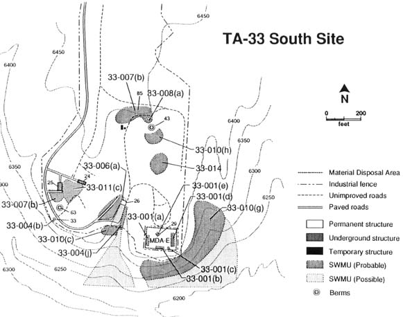
South Site: According to the environmental report, there are three bunkered buildings and a collapsed shaft at South Site. The three bunkered buildings are shown as 24, 25 and 26 on the map.The building shown in Collins' photo* is #25, or more precisely TA-33-25. The collapsed shaft is located in the area marked MDA-E (Material Disposal Area "E"), described as follows:
Physical Description. MDA-E lies on the mesa top and is bounded by Chaquehui Canyon and one of its tributaries. Chaquehui Canyon, in turn, drains into the Rio Grande. MDA-E itself is relatively level, although its southern boundary is only about 50 to 60 ft from the cliff face. The MDA is surrounded by an 8 ft fence. The surface rock has been highly disturbed by the construction of an experimental chamber and six waste pits. There are piles of soil and broken tuff throughout the fenced area.East Site. According to the report, two underground chambers, both about 30 feet below ground, were excavated at East Site in 1948 and subsequently destroyed in Tests. On the map of East Site, the former shafts are the circles marked as 33-003(a) and 33-003(b) in the area designated MDA-D, which is described as follows:Historical Use and Potential Contaminants. Work began in November 1949 on the construction of TA-33-29 (underground Chamber #3). It was completed in February 1950. The chamber shaft was a 6 x 8 x 48 ft deep, with an octagonal test chamber to one side. This chamber was 14 ft in diameter, 11 ft high, and had 2-ft-thick concrete walls, floor, and ceiling. Testing in Chamber #3, SWMU 33-001 (e), involved explosives, beryllium, and tungsten. This underground structure, which lies within the fenced area, collapsed during an experiment in April 1950. The residuals are still contained in the chamber.
The area around Chamber #3 was developed as a disposal area. It contains six pits used for disposal of varied items including spent projectiles, uranium components, beryllium, and shot debris. The contents of two of these pits are unknown. They may or may not have been used. Pits 1 to 4 contain materials contaminated with polonium-210 (now decayed), beryllium, and uranium. Pit 3 may also contain a can of beryllium dust immersed in kerosene; the compositions of the cans are not specified (Ahlquist 1983, 02-006). Use as a disposal area was discontinued in 1963. That year the pits were filled and compacted to mitigate erosion and infiltration of surface water (Zia Job Order #165991,02-030) . The area has been fenced and is designated Material Disposal Area E (MDA-E). [Page 3-51]
Physical Description. MDA-D consists of two areas, each approximately 20 x 30 ft and each containing an underground concrete chamber: Chamber #1, TA-33-4, and Chamber #2, TA-33-6 (SWMUs 33-003[a,b]). TA-33-4 lies east of TA-33-6. MDA-D lies on the east end of the mesa formed by Ancho and White Rock Canyons. These canyons drain into the Rio Grande. The elevation is approximately 6,430 ft and the MDA is relatively level. Very steep cliff faces, 80 to 130 ft high lie to the north and east of the MDA.Chamber #1 was octagonal with dimensions of 16 x 18 ft x 11 ft high. Chamber #2 was also octagonal with dimensions 18 x 18 ft x 16 ft high. Both chambers are about 30 ft below grade. Each chamber had an elevator shaft. The shafts were 4 x 6 ft and 46 ft deep shored with 2 x 2 x 12 ft timbers.
Historical Use and Potential Contaminants. Construction of Chamber#1 was completed January 21,1948, and the chamber was used in an experiment April 14,1948. The experiment did not vent to the surface. No alpha activity was detected in the air or ground immediately after the shot or 24 hours later. This shot probably destroyed the chamber. A berm was later built over the chamber.
Chamber #2 was completed October 8,1948. A polonium-210 bearing experiment was performed in December 1948 (Buckland 1949, 02-033). The chamber was destroyed in an experiment in April 1952 (Blackwell 1952, 02-034). Debris was ejected from the shaft and a 10-ft crater formed. In preparation for the construction of new buildings in the area, MDA-D underwent another radioactivity survey in August 1953. Although the ground showed no detectable alpha counts, timbers and some soil around the crater and soil to a depth of 2 ft gave readings of 500 counts/ min. The contaminated material was bulldozed into the crater and covered with uncontaminated soil. Another radiation survey was made and no radioactive contamination was found (Blackwell 1953,02-035) . The depression above Chamber #2 was refilled in 1963 (Zia Job Order #1 65991, 02-030).
A review of classified reports describing the experiments conducted in these chambers was performed to verify the constituents used in each experiment. This review revealed that uranium was not used in these experiments but beryllium, polonium-210, and high explosives were present.
Present Status. A portion of a berm that was covering Chamber #1 was removed in 1989 for subsurface sampling. The shaft areas to both chambers exhibit depressions typical of soil settling. [Pages 3-67, 3-69]
Physical Description. Shot facility SWMU 33-006(b) consists of two adjacent crescent-shaped berms, each 10 ft high and 200 ft across the face. In the center of each crescent is a concrete shot pad, TA-33-97 and TA-33-98, from west to east. SWMU 33-007(a) lies south of the berms. It is a large area, about 550 x 150-ft. Gun mounts TA-33-116 and TA-33-135 are located at the west end of the area. The mounts are concrete pads. TA-33-151 is 330 ft east of the mounts; a 25 x 35-H metal box filled with sand is adjacent to the building on the west. A narrow asphalt road nuns the length of the SWMU, as does an asphalt drainage ditch. East Site firing range is currently inactive.Historical Use and Potential Contaminants. The buildings at East Site were completed in June 1955. Gun-type, rather than implosion-type, initiators were tested. Uranium projectiles containing beryllium and polonium-210 (half-life 138 days) or cobalt-60 (half-life 5.26 yr) were used in gun tests. The projectiles were not detonated: some were shot into berms and others were shot into catcher boxes for recovery and later sectioning.
Various methods were used to investigate results of the experiments. In one series, neutrons were measured in a large, doughnut-shaped, liquid scintillation counter. In another series, the projectile was x-rayed as it was shot past a recording setup. Projectiles were shot into elaborate catcher boxes, TA-33-118 and TA-33-136. These boxes were 10-ft square on the face and 80-ft deep [long], filled with sawdust. Cobalt-60 needles were included in the test device to facilitate location of the projectile within the boxes.
During a test firing on June 4,1962, a projectile apparently disintegrated in the gun barrel. Cobalt-60 needles and 30 kg of depleted uranium were lost. Fires were ignited in the canyons surrounding the site. A 5-day search by 10 people of the canyon walls and bottoms failed to located more than the front-end piece and a few fragments of the projectile (Russ 1962, 02-037). [Page 3-70]
"The 'front door entry' is suspected to be back down the hill going in an easterly direction away from TA 33 along Rt. 4."
This would have to be TA-39. [See map*] TA-39 is in a canyon below TA-39. Its buildings are sandwiched into the narrow canyon and could conceivably hide entrances to underground facilities at a low lever. However, there is another empty canyon between TA-39 and TA-33, meaning you would have to tunnel under the empty canyon to connect the two areas. TA-39 would not provide a practical entry point to the mesas at TA-33.
From my survey, there is no apparent location below the Mesa top of TA-39 where any bay doors could be located. Conceivably, you might put a camouflaged door anywhere on the cliffside, but there could be no road leading to it, and it would be far easier to bring your alien artifacts through the main gate.
In general, TA-33 is open and exposed to publically accessible lands on all sides. The only place I can conceive of that might be hidden from public view is the canyon between the South and East Sites. On the map, this looks like it has enough of a bend in it that you might not be able look all the way into it from anywhere on the ground. Probably the easiest way to examine this canyon would be to hike into from Bandelier, but this would take most of a day.
Geology. Because geology plays an important role in how hazardous wastes seep through the ground, the RFI Work Plans contains extensive information on the geology of the mesa on which TA-33 is located. A geologist ought to be able to examine this information for clue as to whether underground facilities might be easily constructed here. The report says that "because there are no deep drill holes" within TA-33 [Page 2-5], geology must be inferred from that of nearby mesas. Looking at the cliffs, the mesas here have many differing layers, mostly volcanic outflows. The shallow caves in which the Pueblo indians built their dwellings are in volcanic tuff, soft stone that is easily eroded or excavated. A sign at the scenic turnout at Bandelier [See viewpoints above] describes the area. Although the sign is facing the upper Frijoles Canyon, it also applies to TA-33.
More than a million years ago, the Jemez Volcano spewed ash and pumice, flow after flow, over the area you see. Ash flows covered the land and formed a soft rock called tuff, in some places more than 1000 feet thick.... More than 400 square miles were covered by the ash flows - a wide tableland now known as the Pajarito (little bird) Plateau. Over the years, rain and snow runoff carved deep-walled canyons in the plateau, and gradually the plants and animals returned.... About 700 years ago groups of Pueblo Indians searching for new homes found this area good and settled here.
The park's Juniper Campground is on the mesa near the highway, less than two miles from the TA-33 main gate. The campground is open March-November for about $8/night. Sites are on a first-come/first-serve basis, but the attendant says the campground has never filled up all season. Amenities include running water and restrooms.
I asked a park ranger if he knew anything about the underground alien bases at TA-33 and whether he had seen anything interesting going on there. (The park staff live within view of TA-33 and would be the most likely to notice any mysterious phenomena there.) Although the ranger was interested in the topic and had stories to tell about Area 51, he had not noticed anything unusual about TA-33. He said that the park staff had little contact with anyone there. However, he did say that he had noticed some above-ground construction recently. (I didn't get the specifics.)
Circle Hike Around TA-33. If you were based at the Juniper Campground, it appears you could hike all the way around TA-33 in about a day. See Trail Map. I would start in Ancho Canyon at the other side of TA-33, near TA-39, since the trail on this side is more poorly marked and uncertain, and I think it would be easier to navigate going down. Start by following the dirt road through the meadow near the entrance of TA-39 (in Ancho Canyon below TA-33 on Route 4). Signs at the gate say the area is for day use only and warn you not to disturb archeological sites. The dirt road leads to a water monitoring station, then becomes a cliff-hugging trail just below the Main Site of TA-33. I didn't get very far down this trail before being turned back by darkness, so I don't know what it is like down to the Rio Grande, but the Los Alamos Hiking Trails map (available for sale from us) suggests it is probably passable. (The dotted line on the map indicates that the trail is shown on other maps but has not been confirmed.) At the Rio Grande, another hypothetical trail leads along the river to the mouth of the Frijoles Canyon at Bandelier, where the Falls Trail - presumably well marked by the Park Service - leads up the canyon to the Visitor's Center. The distance from TA-39 down to the river looks like about 2-1/2 miles; the distance along the river appears to be another 2-1/2 miles, and then back to the visitor center is 2-1/2 miles more, for a total of 7-1/2 rugged miles, not including road distances between the start and end of the trail (add about 5 miles).
Bandelier External Links
My reply:
The environmental maps & reports are still useful, since they tell you where the secret stuff _isn't_. If any area is off limits or can't be reported on, the report should say so, or the environmental reports will be kept secret altogether as at Area 51. The person who surveys the site for the environmental report is usually an outside contract employee. Of course, he can go only where the tenant lets him go and can inspect only what documents he has access to, but I assume he is obligated to report any significant absences. He's going to make some notation in his report that shifts responsibility for the missing data to another party.He may not be granted access to every building, but he can report surface disturbances, which ought to be highly relevant to any underground facilities. The quantity of tailings dumped in a nearby canyon is of great concern to the environmental survey. In my view, you are getting the government to collect intelligence for you, and do it far more efficiently that can be done from behind the fence.
I have a basic faith in the environmental reporting process. At Los Alamos, as at other installations like the Nevada Test Site, there are many different groups with competing agendas, and the obligation of the environmental contractors is to report, in detail, the actual condition of each site, not to protect alien artifacts. I'm sure it causes them great frustration when they are not given the information they need to do their job, and if their access is barred in some way, I think this would show up in the report.
It is really tough to come up with a cover story for everything, especially one that is deep enough to consistantly fool the other workers at Los Alamos. The environmental reports are where I would expect the cover story to start unraveling.
| Reader Comments | Regarding "Los Alamos - TA-33" - Latest First |
|
|
Created: 8/15/96 gc
Last Modified: 11/19/96 gc.e