
| Links | |
| Books |
|
|
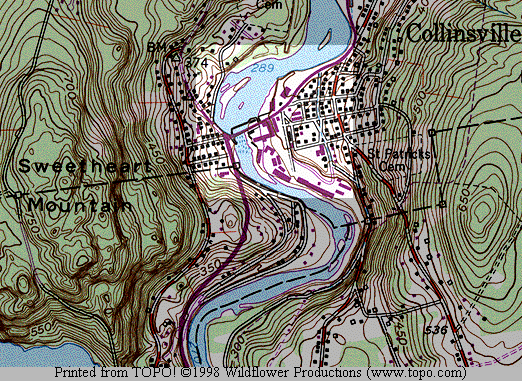
Local Area (Collinsville - Bridge St)
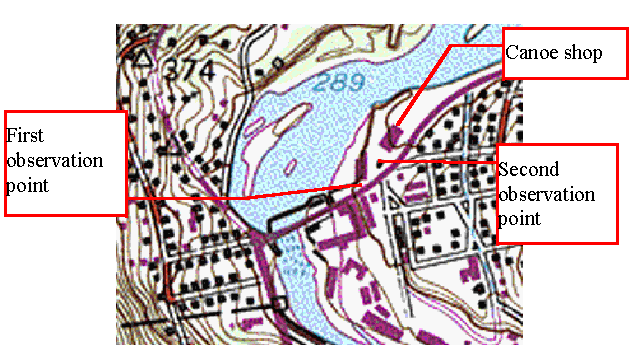
Local Area With Important Sighting Points Indicated
Coordinates for Second Observation Point: 41.81120 (Lat), -72.92348 (Long)
|
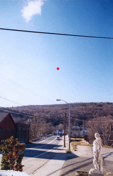
Looking almost directly West toward the bridge. The red spot marks the approximate origination elevation and azimuth of the contrails, which terminated at the horizon. Taken 10:00 AM, December 24, 1999 |
 |
|
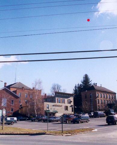
Looking toward the South East. The red spot marks the approximate initial elevation and azimuth of the observed objects. The primary witness indicated the length of the "bullet-shaped" object had the same angular size as the roofline of the brownstone building to the right. Taken 10:00 AM, December 24, 1999 |
 |
|
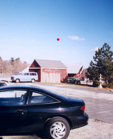
Looking toward the North North East. The red spot marks the approximate azimuth and elevation of the objects as they disappeared in plain view. The building beyond the shed is the canoe shop. Taken 10:00 AM, December 24, 1999 |
 |
The primary purpose of the first site visit was to observe the location and interview the primary witness. The area is an aged mill town, and the sighting location is to the east of a river that at least at one time was used by the local industry. There are two antique stores, the industrial buildings to the south, and what appears to be town hall / public safety buildings to the East. A canoe sales (and rental?) business is to the north north east. Photos were taken but no detailed look around the town.
The area is rimmed with hills to the West - South and North. There is also a rise to the East. The terrain is forested, with a combination of deciduous trees and conifers, deciduous trees being the dominant type.
The contrails disappeared over a hill beyond which a reservoir is located.
The purposes of the second site visit were
Perform a tour of the area to become familiar with major features.
Obtain a detailed map of the downtown Collinsville area.
Determine the possible source / type of birds mentioned in the account.
Determine the correctness of the sun analysis by direct observation.
Perform a search for any debris which might have been resulting from a hoax perpetrated by a third party on the witnesses (i.e. balloons, etc.)
Determine if a search of Sweetheart Mountain for debris from the contrail source was feasible, in the event it became justified by research results.
Determine the type and quantity of local air traffic on the same day of the week / time as the observations.
Informally canvass if the opportunity was presented.
The following results were obtained:
Perform a tour of the area to become familiar with major features - I was able to drive around most of the areas in the directions observed. These included:
The top of the hill to the South East, including a look at the tall conifer (seen from Observation Point 2). That tree is about seventy feet tall. The town hall also has a tall radio antenna with many projecting aerials. A historical society operates a museum in that area, but it is only open on weekends in the winter.
The canoe shop seen from Observation Point 2.
Cavalry Cemetary - on a direct line from the canoe shop / Observation Point 2 and the tall conifer. Interestingly, the footings for an old bridge cross the river and point directly toward the garage over which the objects were seen to disappear (see the photo of Observation Point 3).
Sweetheart Mountain - (the mountain toward which the contrails were directed) I drove South West to Rt 4 and then North on Barnes Hill Rd past the Phelps Dam. The top of the mountain may be accessible to hikers, but there is no road.
Obtain a detailed map of the downtown Collinsville area - I was unable to find any such map so far. The town engineer and town planner were both unavailable.
Determine the possible source / type of birds mentioned in the account - Three types of birds were observed in the post 3:30 PM time frame: Starlings, flying South West to North East and vice versa, apparently heading to / from roosting areas South West of the town center; seagulls, flying essentially South to North; geese, flying East to West. Flocking behavior among the starlings was normal within that time frame and may suggest that the behavior of the birds during the sighting was coincidental. Specific starting point and direction of the bird flock should be determined from the witnesses.
Determine the correctness of the sun analysis by direct observation - The sun was seen to touch the mountain shortly after the 3:30 time frame, slightly later as would be expected to result from the passage of two weeks. Thus, the shadow predicted by the sun analysis is confirmed.
Perform a search for any debris which might have been resulting from a hoax perpetrated by a third party on the witnesses (i.e. balloons, etc.) - One possible analysis of the second incident might be that the objects seen were balloons (which was suggested by one of the witnesses). If so, it would be possible (though unlikely) that the disappearance of the objects would be from the balloon having burst. I examined the dam on the river, the trees on the far side of the river (starting at the cemetary and working south to the shore), the shore on the far side of the river, and the side of the road from there, south along 179. The only finding of note was a grey plastic sheet found, photographed in situ and removed for examination. This sheet was in an incorrect location (South West of the sighting location), formed no particular shape suggestive of the reported objects, bore a large printed tag, was partly buried in leaves and somewhat frozen to the ground. Nevertheless, the material was removed for further examination, and to allow a sample to be shown to the witnesses, in light of their description of the object color and lustre.
Determine if a search of Sweetheart Mountain for debris from the contrail source was feasible, in the event it became justified by research results - The size and lack of access to Sweetheart Mountain means that a specific and high probability of finding physical evidence would be needed to justify a search. No road seems to lead to the top, so all access would need to be on foot.
Determine the type and quantity of local air traffic on the same day of the week / time as the observations - The day was partly / mostly cloudy, so opportunities for observing air traffic were limited. Nevertheless, only two distant, high altitude airliners were observed during the visit.
Informally canvass if the opportunity was presented - Four people were questioned. 1) a woman ice fishing on the far side of the river, who believed the ice had not formed at that time and had not seen anything, 2) a bicyclist on 179 was asked if he biked that road every day about the same time, but he did not, and, in any event, had seen nothing; 3) two employees of the canoe shop, only one of which was working that day - neither had seen anything.
This site is an archive of the content of the MUFON CT website from the late 1990s. The current MUFON CT organization should be contacted through the MUFON web site.